Machame
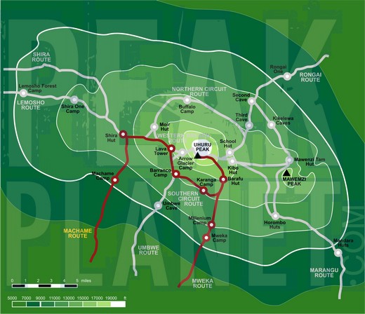
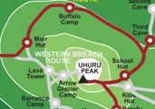
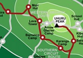
The Machame route is a popular but challenging route up Mount Kilimanjaro. Known as the Whiskey Route, the Machame route begins at Machame gate and ascends north to the Shira Plateau. The route then traverses the southern side of the mountain before summiting from Barafu Hut. The descent is by Mweka.
The Machame route is a good choice for those who want a difficult path with a reasonable acclimatization profile, and also does not mind crowds. The route costs less than other camping routes due to its short access drive and fewer days on the mountain.
The Machame route measures 30 miles (49 km) in distance and takes 6-7 days total.
ITINERARY |
|
DAY 1 |
Arrive anytime in Arusha, Tanzania. |
DAY 2 |
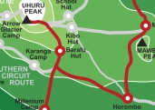
After completing the necessary registration formalities at Machame National Park gate, we begin to trek through a beautiful and lush forest. We have a picnic lunch en route. We camp at Machame Camp (9,800 ft). [5-6 hours walking] |
DAY 3 |
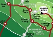
We soon leave the forest behind and enter the moorland zone of giant heather. The trail climbs steadily through rocky hills with wide views of the Shira Plateau. From our camp nearShira Hut (12,600 ft), we take in the unforgettable views of Mt. Meru as she floats among the clouds. [4-5 hours walking] |
DAY 4 |
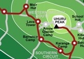
A morning of sustained ascent and panoramic views brings us to lunch near Lava Tower(14,900 ft). The trail then descends to the bottom of the Barranco Valley (12,800 ft), where we stay in the spectacular Barranco Campsite sheltered by towering cliffs and with extensive views of the plains far below. [7-9 hours walking] |
DAY 5 |
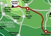
A steep climb up the Barranco Wall leads us to an undulating trail on the south-eastern flank of Kibo, with superb vistas of the Southern Icefields. The terrain changes to scree, with pockets of lush vegetation in sheltered hollows, and there is only a short distance to our camp at Karanga Camp (13,100 ft), the last water point on the approach to the summit. [5-7 hours walking] |
DAY 6 |
We follow an easy path on compacted scree with wide views that gains altitude unrelentingly to reach Barafu Hut (14,800 ft) for lunch. There is a short acclimatisation hike to the plateau at the bottom of the southeast valley (15,700 ft). The remainder of the day is spent resting in preparation for the early morning final ascent. [3-5 hours walking] |
DAY 7 |
We start our ascent by torchlight about 1 a.m. so that we can be up on the crater rim by sunrise. The steep climb over loose volcanic scree has some well-graded zig-zags and a slow but steady pace will take us to Stella Point (18,800 ft), in about five or six hours. We will rest there for a short time to enjoy the sunrise over Mawenzi. Those who are still feeling strong can make the two-hour round trip from here along the crater rim to Uhuru Peak(19,345 ft), passing close to the spectacular glaciers and ice cliffs that still occupy most of the summit area. The descent to Barafu is surprisingly fast, and after some refreshments, we continue to descend to reach our final campsite, Millenium Camp (12,500 ft). [11-15 hours walking] |
DAY 8 |
A sustained descent on a well constructed path takes us through a lovely tropical forest alive with birdsong and boasting lush undergrowth with considerable botanical interest. Our route winds down to the Kilimanjaro National Park gate at Mweka (5,400 ft); and on through coffee and banana farms to Mweka village, where we are transferred to Arusha. [4-6 hours walking] |
DAY 9 |
After breakfast, we can arrange for a private transfer or taxi to Kilimanjaro International Airport (JRO). |
Pros:
- Great scenery
- Good acclimatization profile
- Moderate success rate
- Good option for shorter trek
- Lowest cost of camping routes
Cons:
- Crowded
Climb Kilimanjaro on the Machame route.